Uherské Hradiště - Zlechov - Břestecké skály - Buchlovice - Uherské Hradiště
A diverse trip that will take travelers around Uherské Hradiště. You will visit both natural monuments and famous historic buildings. The route is more demanding in terms of distance and in the Břestecké skály nature reserve it overcomes a relatively large elevation gain. It can therefore be recommended to recreational cyclists rather than as a family trip.

Information for visitors
Interesting facts Uherské Hradiště - Zlechov - Břestecké skály - Buchlovice - Uherské Hradiště
Before leaving the city, take a short walking tour of the center. There are several places worth visiting here - for example, the Jesuit Garden directly opposite the train station, the nearby large area of the Slovácko Museum and also the Uherské Hradiště Synagogue.
From the railway station, take Nádražní Street to the cadastral office, where you will catch intermittent red lane markings. It zigzags through the city center to the river, where it is directly connected to the cycle route No. 47 - Moravská vinná. Cross the bridge over it and keep to its markings. It copies the flow of the river and then joins the tracks. At the intersection with Na vyhlídce street, leave the trail and continue along this street. You will follow it to Nádražní Street, but this time in the Old Town. Here it will be joined by the marking of the cycle route 5151A which will take you out of the city.
Along its surface, you will get to the village of Zlechov, where it is necessary to be careful to turn to the directly neighboring village of Tupesy. This whole section takes place in a flat unforested landscape. The Museum of Tupes Ceramics is located in the center of Tupes. Not far from it, the village is crossed by cycle route No. 5150, which you will continue towards in the village of Břestek. The crossing between the villages is rising, but the ascent is mild. You will pass through the corridor without a major change of direction, but the cycle route will change to the number 5050.
In the upper part of the village, the ascent begins to rise. In terms of length, Brest is really long. A strip of vineyards follows the path on your right. Soon your path will meet the turnoff, but you will go straight again and the marking of your path will now have the number 5159. This will take you within sight of the Natural Monument of Břestecká skála.
The red markings will lead you directly to the rock massif via the signpost "Pod Břesteckou skalkou" and "Břestecká skála - odb.". It is better to conquer this part of the trip on foot. From the rocks there is a beautiful view of the surrounding countryside and you can find specific fauna and flora.
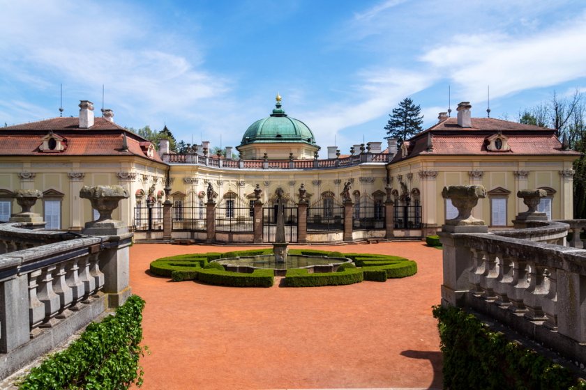
From the first crossroads, head back. So follow the red sign towards the crossroads "Pod Barborkou". The path leads through the forest after a steep descent - here it is also better to combine the descent with the bike. From the crossroads, the yellow sign will take you after a gentle descent to the village of Buchlovice with an information center, a beautiful castle and the castle park and museum. Buchlovice Chateau is a very well-known term, multicolored peacocks walk through its courtyard and many interesting woody plants and flowers grow in the surroundings.
For a more comfortable and calmer way to the destination of the trip, choose Hradištská Street, after passing a short gap you will find yourself in the village of Zlechov, and thus close the whole way by returning along the route.
Author: Martina Zapletalová