Bílá Opava
The Bílá Opava river springs at an altitude of 1280 m on the southern slopes of Praděd near the Barborka cottage. Its upper course has been a nature reserve since 1963, do not hesitate and go directly to its center.
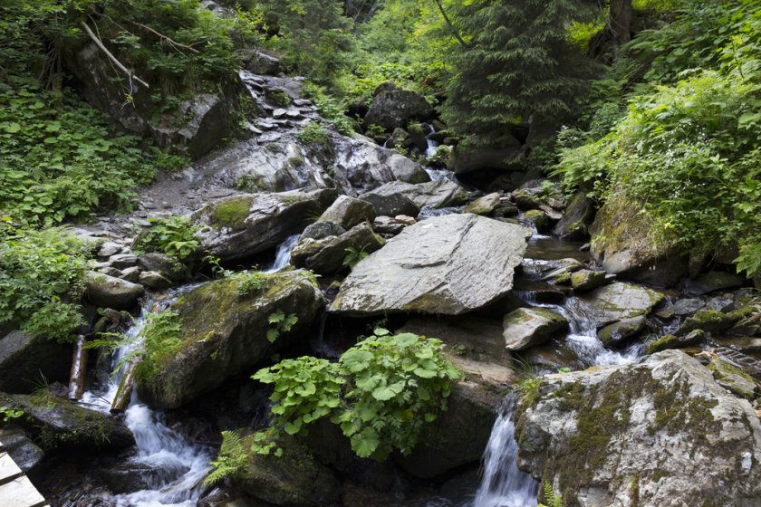
The yellow tourist sign, connected to the nature trail, will take you through a canyon where you can observe rapids. Here the road is divided into the extremely challenging and milder, leading along the edge of the canyon. If you decide for a more demanding route, marked with a yellow sign, the most beautiful 2 km of the Jeseníky Mountains await you. You will have to overcome many footbridges and ladders rising high above the riverbed, walk just past the waterfalls or along a path secured only by chains. The road then connects with the blue tourist sign and is then passable without major problems. The yellow trail is closed to tourists in winter.
On the way along the nature trail, which numbers a total of 10.5 km, you will pass seven information boards that offer basic information about nature. Here you will learn, among other things, that protected plants such as the alpine rose, the Czech havez, the alpine fern and the alpine milkweed grow here. Of the animals, there are many especially protected birds, such as the mountain wagtail, the water cinquefoil, the great tit, and the smallest wagtail. We must not forget the Sudeten squirrel, which lives here and no one else. If you go on the trail early in the morning, you may be lucky and meet big game or chamois that move in these forests.
Numerous rapids and waterfalls were created thanks to different rocks, each of which has a different ability to resist water erosion and weathering. Some gneiss boulders were washed away by the river into the form of so-called pots, which we know from Mumlava. The largest waterfall in Bílá Opava is the Velký waterfall, 7.9 m high. The torrent overcomes the height difference of 17 m with this waterfall and the adjoining rapids.
In 1997, many footbridges and a bridge were demolished due to floods. The river overflowed from the original riverbed and found new ones. Another catastrophe that destroyed this beautiful place was a storm in 2005. Many trees were uprooted and broken, the soil collapsed, and repaired bridges were destroyed again. So part of the trail now leads through a clearing.